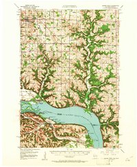
1950 Map of Maiden Rock
USGS Topo · Published 1961About this map
The Mississippi River and the broad waters of Lake Pepin dominate this mid-century landscape at the border of Wisconsin and Minnesota. This survey documents a rural economy defined by a high density of country schools and churches, including Hill and Dale Sch, Fischer Sch, and St Marys Ch. The riverfront is a site of significant activity, where the Chicago Burlington and Quincy railroad skirts the eastern shore through Stockholm and Maiden Rock. On the Minnesota side, the settlement of Old Frontenac and the Villa Maria Academy sit above the water, while the Wacouta Cem and Red Wing Airport mark the area near Wacouta. The topography reveals the deeply incised valleys of Rush River and Isabelle Creek as they descend toward the river valley, a pattern that influenced the placement of early crossroads such as Snows Corner and Ono.
Find a feature on this map
102 named features on this map. Tap any name to fly to it.
Don’t see what you’re looking for? This feature index may not catch every label — zoom into the map to look around manually.
Map Details
Editions of this 1950 Maiden Rock Map
4 editions found

Other maps of this area

1932 · Wabasha
USGS Topo · 1:62,500

1935 · Arkansaw
USGS Topo · 1:48,000

1940 · Maiden Rock
USGS Topo · 1:62,500

1941 · Arkansaw
USGS Topo · 1:62,500

1942 · Arkansaw
USGS Topo · 1:62,500

1944 · Red Wing
USGS Topo · 1:62,500

1946 · Knapp
USGS Topo · 1:62,500

1946 · River Falls
USGS Topo · 1:62,500

1949 · River Falls
USGS Topo · 1:62,500

1949 · Knapp
USGS Topo · 1:62,500