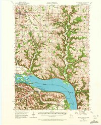
1950 Map of Maiden Rock
USGS Topo · Published 1972About this map
The Mississippi River and Lake Pepin dominate this mid-century landscape, serving as the defining border between Pierce County, Wisconsin, and Goodhue County, Minnesota. The terrain is a network of deep coulees and ridges, where rural life in the 1930s and 40s was anchored by numerous one-room schoolhouses like Sleepy Hollow Sch and Maple Grove Sch, alongside community churches such as St Pauls Ch and the Mission Ch.
Find a feature on this map
90 named features on this map. Tap any name to fly to it.
Don’t see what you’re looking for? This feature index may not catch every label — zoom into the map to look around manually.
Map Details
Editions of this 1950 Maiden Rock Map
4 editions found

Other maps of this area

1932 · Wabasha
USGS Topo · 1:62,500

1935 · Arkansaw
USGS Topo · 1:48,000

1940 · Maiden Rock
USGS Topo · 1:62,500

1941 · Arkansaw
USGS Topo · 1:62,500

1942 · Arkansaw
USGS Topo · 1:62,500

1944 · Red Wing
USGS Topo · 1:62,500

1946 · Knapp
USGS Topo · 1:62,500

1946 · River Falls
USGS Topo · 1:62,500

1949 · River Falls
USGS Topo · 1:62,500

1949 · Knapp
USGS Topo · 1:62,500