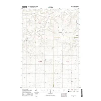
2016 Map of Lake City NW
USGS Topo · Published 2016About this map
The boundary between Goodhue and Wabasha counties cuts through this undulating agricultural landscape, where the headwaters of Wells Creek and Gilbert Creek have carved distinct drainage patterns. For genealogists and local historians, this map is remarkable for its concentration of denominational and family burial sites, including the German Lutheran Cemetery, German Methodist Cemetery, and the Old German Evangelical Cemetery, which reflect the area's European immigrant heritage. The settlement of Oak Ridge sits on the eastern edge, while prominent landforms like West Florence Ridge and the Gilbert Valley dominate the central and southern portions of the quadrangle. The road network follows a blend of section lines and topography, with routes such as County 5 Boulevard and Old Church Road connecting the scattered farmsteads and rural landmarks.
Find a feature on this map
56 named features on this map. Tap any name to fly to it.
Don’t see what you’re looking for? This feature index may not catch every label — zoom into the map to look around manually.
Map Details
Editions of this 2016 Lake City NW Map
This is the sole edition of this map. No revisions or reprints were ever made.
Other maps of this area

1940 · Maiden Rock
USGS Topo · 1:62,500

1944 · Red Wing
USGS Topo · 1:62,500

1950 · Maiden Rock
USGS Topo · 1:62,500

1951 · Lake City
USGS Topo · 1:62,500

1952 · Red Wing
USGS Topo · 1:62,500

1953 · Saint Paul
USGS Topo · 1:250,000

1959 · Saint Paul
USGS Topo · 1:250,000

1968 · Goodhue East
USGS Topo · 1:24,000

1968 · Mazeppa
USGS Topo · 1:24,000
1974 · West Albany
USGS Topo · 1:24,000
Featured Places
- Belvidere Township, MN
- Hay Creek Township, MN
- Florence Township, MN
- Goodhue County, MN
- Wabasha County, MN