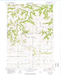
1974 Map of Lake City NW
USGS Topo · Published 1976About this map
Minnesota Memorial Hardwood State Forest occupies the central portion of this 1974 survey, a landscape defined by the deep valleys and high ridges that characterize this region of Goodhue and Wabasha counties. The map captures a primarily rural agricultural era, where farmstead boundaries and field lines are clearly delineated by fine red dashed lines. Significant local landmarks for genealogists include St Peters Ch and West Florence Immanuel Ch, which serve as community anchors alongside the Wells Creek Cem and Belvidere Union Cem. The drainage pattern is led by Wells Creek, which winds through the northwestern corner, and Gilbert Creek to the east, while the lone industrial marker of a Quarry and the small settlement of Stameier reflect the sparse but established human footprint across Hay Creek and Belvidere townships.
Find a feature on this map
19 named features on this map. Tap any name to fly to it.
Don’t see what you’re looking for? This feature index may not catch every label — zoom into the map to look around manually.
Map Details
Editions of this 1974 Lake City NW Map
This is the sole edition of this map. No revisions or reprints were ever made.
Other maps of this area

1940 · Maiden Rock
USGS Topo · 1:62,500

1944 · Red Wing
USGS Topo · 1:62,500

1950 · Maiden Rock
USGS Topo · 1:62,500

1951 · Lake City
USGS Topo · 1:62,500

1952 · Red Wing
USGS Topo · 1:62,500

1953 · Saint Paul
USGS Topo · 1:250,000

1959 · Saint Paul
USGS Topo · 1:250,000

1968 · Goodhue East
USGS Topo · 1:24,000

1968 · Mazeppa
USGS Topo · 1:24,000
1974 · West Albany
USGS Topo · 1:24,000
Featured Places
- Florence Township, MN
- Hay Creek Township, MN
- Belvidere Township, MN
- Goodhue County, MN
- Wabasha County, MN