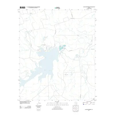
2013 Map of Lake Diversion
USGS Topo · Published 2013About this map
Lake Diversion serves as the central focal point of this North Texas landscape, where the Wichita River is managed for regional water needs. The surrounding terrain in Wichita County reflects a blend of cattle ranching and energy extraction, characterized by the sprawling interests of the Waggoner estate, including Waggoner Ranch Lake Number 4 and Waggoner Ranch Lake Number 5. The industrial character of the region is evident through the Potts Oil Field and Kadane Oil Field, marking decades of petroleum production. Near the river's eastern bend, the Dundee Fish Hatchery stands as a significant landmark of local resource management. Smaller water features like Blackberry Cr and Palo Pinto Tank dot the plains, connected by a network of ranch roads such as Bradley Ranch Rd and Toll Gate Rd.
Find a feature on this map
24 named features on this map. Tap any name to fly to it.
Don’t see what you’re looking for? This feature index may not catch every label — zoom into the map to look around manually.
Map Details
Editions of this 2013 Lake Diversion Map
This is the sole edition of this map. No revisions or reprints were ever made.
Other maps of this area

1916 · Fowlkes
USGS Topo · 1:24,000

1917 · Beaver Creek
USGS Topo · 1:24,000

1919 · Fowlkes
USGS Topo · 1:31,680

1920 · Beaver Creek
USGS Topo · 1:31,680

1932 · Dundee
USGS Topo · 1:62,500

1954 · Wichita Falls
USGS Topo · 1:250,000

1958 · Wichita Falls
USGS Topo · 1:250,000

1963 · Dundee
USGS Topo · 1:24,000
1966 · Mankins
USGS Topo · 1:24,000

1966 · Franklin Bend
USGS Topo · 1:24,000