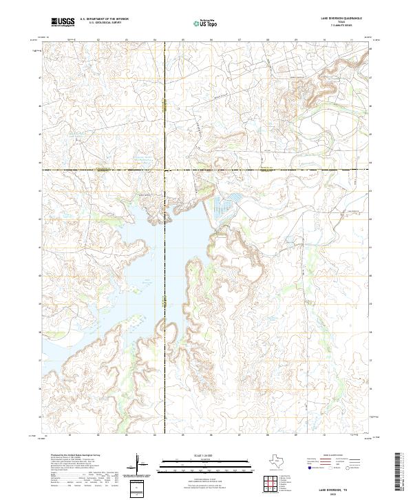
2022 Map of Lake Diversion
USGS Topo · Published 2022About this map
Lake Diversion dominates this North Texas landscape, a critical point where the Wichita River is managed across the convergence of Archer, Baylor, Wichita, and Wilbarger counties. The map illustrates the specialized water management and ranching infrastructure characteristic of the region, including the Waggoner Ranch Lake Number 4 and Waggoner Ranch Lake Number 5. These private ranching features, along with names like Palo Pinto Tank, highlight the enduring legacy of large-scale landholdings in the area. Local access is defined by a network of ranch and farm-to-market roads, such as FM 1180 and the uniquely named Easter Sunday Rd. The drainage patterns of Blackberry Cr and Brushy Cr reveal the intricate topography surrounding the reservoir, providing a clear view of the hydrological interface between the river system and the surrounding cattle country.
Find a feature on this map
23 named features on this map. Tap any name to fly to it.
Don’t see what you’re looking for? This feature index may not catch every label — zoom into the map to look around manually.
Map Details
Editions of this 2022 Lake Diversion Map
This is the sole edition of this map. No revisions or reprints were ever made.
Other maps of this area

1916 · Fowlkes
USGS Topo · 1:24,000

1917 · Beaver Creek
USGS Topo · 1:24,000

1919 · Fowlkes
USGS Topo · 1:31,680

1920 · Beaver Creek
USGS Topo · 1:31,680

1932 · Dundee
USGS Topo · 1:62,500

1954 · Wichita Falls
USGS Topo · 1:250,000

1958 · Wichita Falls
USGS Topo · 1:250,000

1963 · Dundee
USGS Topo · 1:24,000
1966 · Mankins
USGS Topo · 1:24,000

1966 · Franklin Bend
USGS Topo · 1:24,000