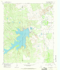
1966 Map of Lake Diversion
USGS Topo · Published 1968About this map
Lake Diversion dominates the landscape of this mid-1960s survey, marking a significant point of water management where the Wichita River is diverted for irrigation and municipal use. The map captures the infrastructure of the Texas Rolling Plains, showing the South Side Canal and the detailed layout of the Dundee Fish Hatchery just below the dam. This era was characterized by the intersection of water conservation and the petroleum industry, evidenced by the extensive Potts Oil Field to the north and the Kadane Oil Field to the south. Local landmarks like the Clear Lake Landing Strip and Palo Pinto Tank provide specific points of interest for researchers tracing the development of Archer and Wichita Counties. The map also delineates the intricate boundaries where Baylor, Wilbarger, Archer, and Wichita Counties meet amidst a network of seasonal drainages like Sadler Creek and Blackberry Creek.
Find a feature on this map
18 named features on this map. Tap any name to fly to it.
Don’t see what you’re looking for? This feature index may not catch every label — zoom into the map to look around manually.
Map Details
Editions of this 1966 Lake Diversion Map
This is the sole edition of this map. No revisions or reprints were ever made.
Other maps of this area

1916 · Fowlkes
USGS Topo · 1:24,000

1917 · Beaver Creek
USGS Topo · 1:24,000

1919 · Fowlkes
USGS Topo · 1:31,680

1920 · Beaver Creek
USGS Topo · 1:31,680

1932 · Dundee
USGS Topo · 1:62,500

1954 · Wichita Falls
USGS Topo · 1:250,000

1958 · Wichita Falls
USGS Topo · 1:250,000

1963 · Dundee
USGS Topo · 1:24,000
1966 · Mankins
USGS Topo · 1:24,000

1966 · Franklin Bend
USGS Topo · 1:24,000