1977 Map of Lake Drummond
USGS Topo · Published 1978About this map
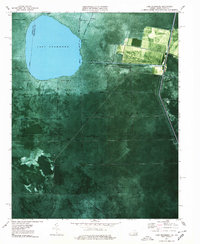
Lake Drummond sits at the heart of this orthophotomap, a 1970s aerial perspective showing the complex water-management system within the Great Dismal Swamp National Wildlife Refuge. The map reveals an intricate network of historical waterways including Jericho Ditch, Washington DITCH, and Feeder Ditch, which crisscross the swamp and reflect centuries of efforts to drain and navigate this distinctive landscape.
Find a feature on this map
37 named features on this map. Tap any name to fly to it.
Don’t see what you’re looking for? This feature index may not catch every label — zoom into the map to look around manually.
Map Details
Editions of this 1977 Lake Drummond Map
2 editions found

Other maps of this area

1906 · Beckford
USGS Topo · 1:48,000

1907 · Beckford
USGS Topo · 1:62,500

1919 · Suffolk
USGS Topo · 1:62,500

1940 · Beckford
USGS Topo · 1:62,500

1940 · Lake Drummond
USGS Topo · 1:62,500

1940 · South Mills
USGS Topo · 1:62,500

1945 · Lake Drummond
USGS Topo · 1:62,500

1952 · South Mills
USGS Topo · 1:62,500

1953 · Norfolk
USGS Topo · 1:250,000

1954 · Corapeake
USGS Topo · 1:24,000