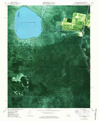
1977 Map of Lake Drummond
USGS Topo · Published 1987About this map
Lake Drummond sits at the heart of this orthophotomap, surrounded by the dense, waterlogged forests of the Great Dismal Swamp. The 1970s landscape reveals an intricate hydrological network designed to manage the swamp's interior, including the historic Washington Ditch and Feeder Ditch. This era marks a significant conservation period, with boundaries clearly delineated for the Great Dismal Swamp National Wildlife Refuge in Virginia and the Dismal Swamp State Park extending into North Carolina. Human presence is concentrated along the eastern edge, where the Dismal Swamp Highway skirts the wetlands. Settlements and stop-offs such as Wallaceton, Arbuckle Landing, and Angle Siding represent the thin margin of development against the wilderness. The use of aerial photography combined with topographic data highlights the stark contrast between the geometrically straight drainage canals like Cross Canal and the natural circularity of the lake.
Find a feature on this map
35 named features on this map. Tap any name to fly to it.
Don’t see what you’re looking for? This feature index may not catch every label — zoom into the map to look around manually.
Map Details
Editions of this 1977 Lake Drummond Map
2 editions found
Other maps of this area

1906 · Beckford
USGS Topo · 1:48,000

1907 · Beckford
USGS Topo · 1:62,500

1919 · Suffolk
USGS Topo · 1:62,500

1940 · Beckford
USGS Topo · 1:62,500

1940 · Lake Drummond
USGS Topo · 1:62,500

1940 · South Mills
USGS Topo · 1:62,500

1945 · Lake Drummond
USGS Topo · 1:62,500

1952 · South Mills
USGS Topo · 1:62,500

1953 · Norfolk
USGS Topo · 1:250,000

1954 · Corapeake
USGS Topo · 1:24,000