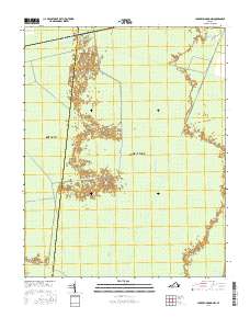
2016 Map of Lake Drummond NW
USGS Topo · Published 2016About this map
The Great Dismal Swamp dominates this landscape, showing the complex hydrology of one of the mid-Atlantic's most significant wetlands. This territory, split by the boundary between the City of Suffolk and City of Chesapeake, is defined by an extensive network of historic canals and drainage routes. Features like Washington Ditch, Jericho Ditch, and Williamson Ditch illustrate the long-term engineering efforts to manage water within the swamp, while the Intracoastal Waterway cuts through the southeastern corner. These waterways, alongside terrestrial markers such as Hardwood Leg and Hardwood Ditch, reveal the intersection of natural conservation and human-altered environments. The presence of Jericho Ditch Ln and Kentucky Trl provides specific points of access for those researching the modern infrastructure of this protected wilderness area.
Find a feature on this map
18 named features on this map. Tap any name to fly to it.
Don’t see what you’re looking for? This feature index may not catch every label — zoom into the map to look around manually.
Map Details
Editions of this 2016 Lake Drummond NW Map
This is the sole edition of this map. No revisions or reprints were ever made.
Other maps of this area

1907 · Norfolk
USGS Topo · 1:125,000

1919 · Smithfield
USGS Topo · 1:62,500

1919 · Suffolk
USGS Topo · 1:62,500

1921 · Newport News
USGS Topo · 1:62,500

1940 · Lake Drummond
USGS Topo · 1:62,500

1944 · Norfolk South
USGS Topo · 1:25,000

1945 · Lake Drummond
USGS Topo · 1:62,500

1948 · Norfolk South
USGS Topo · 1:24,000

1949 · Chuckatuck
USGS Topo · 1:24,000
1952 · Bowers Hill
USGS Topo · 1:24,000