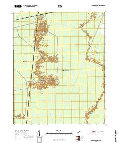
2019 Map of Lake Drummond NW
USGS Topo · Published 2019About this map
The Great Dismal Swamp dominates this landscape on the border of Suffolk and Chesapeake, Virginia, revealing an intricate network of artificial waterways that have shaped this environment for centuries. This survey illustrates the geometric precision of the drainage and transportation system, featuring prominent canals such as the Washington Ditch, Jericho Ditch, and Williamson Ditch. These straight-line water features, alongside trails like Kentucky Trl and the Hardwood Peg path, provide a detailed look at how the swamp has been managed and navigated into the modern era. In the southeast corner, the Intracoastal Waterway cuts through the terrain, serving as a vital artery for coastal transit. The map is a significant resource for understanding the hydrography and man-made infrastructure within one of the Atlantic seaboard's most distinct wetland ecosystems.
Find a feature on this map
16 named features on this map. Tap any name to fly to it.
Don’t see what you’re looking for? This feature index may not catch every label — zoom into the map to look around manually.
Map Details
Editions of this 2019 Lake Drummond NW Map
This is the sole edition of this map. No revisions or reprints were ever made.
Other maps of this area

1907 · Norfolk
USGS Topo · 1:125,000

1919 · Smithfield
USGS Topo · 1:62,500

1919 · Suffolk
USGS Topo · 1:62,500

1921 · Newport News
USGS Topo · 1:62,500

1940 · Lake Drummond
USGS Topo · 1:62,500

1944 · Norfolk South
USGS Topo · 1:25,000

1945 · Lake Drummond
USGS Topo · 1:62,500

1948 · Norfolk South
USGS Topo · 1:24,000

1949 · Chuckatuck
USGS Topo · 1:24,000
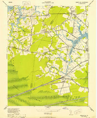
1952 · Bowers Hill
USGS Topo · 1:24,000