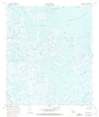
1955 Map of Lake Eugenie
USGS Topo · Published 1975About this map
Lake Eugenie and the surrounding marshlands of St. Bernard Parish appear in this mid-century survey as a complex network of coastal waterways and brackish basins. The terrain is dominated by vast expanses of swamp and open water, where major tidal channels like Bayou La Loutre and Biloxi Bayou provide navigation through the wetlands. The coastline is deeply indented by False Mouth Bay and Bay Boudreau, with small landmarks like Pirate Point and Wild Goose Island breaking the horizon. Local history is reflected in names like Lake of the Mound, which suggests the presence of indigenous earthworks, and Stump Lagoon, likely named for its submerged cypress remains. A prominent Spoil Bank along the southern bayou indicates early dredging activity and maritime infrastructure in this water-bound landscape.
Find a feature on this map
23 named features on this map. Tap any name to fly to it.
Don’t see what you’re looking for? This feature index may not catch every label — zoom into the map to look around manually.
Map Details
Editions of this 1955 Lake Eugenie Map
3 editions found
Other maps of this area

1893 · Rigolets
USGS Topo · 1:62,500

1893 · Shell Beach
USGS Topo · 1:62,500

1893 · Toulme
USGS Topo · 1:62,500

1895 · Bodreau
USGS Topo · 1:62,500

1935 · Morgan Harbor
USGS Topo · 1:31,680

1936 · Rigolets
USGS Topo · 1:62,500

1939 · Shell Beach
USGS Topo · 1:62,500

1941 · Shell Beach
USGS Topo · 1:62,500

1946 · Oak Mound Bayou
USGS Topo · 1:31,680

1946 · Lake Eugenie
USGS Topo · 1:31,680