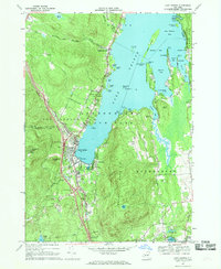
1966 Map of Lake George
USGS Topo · Published 1969About this map
The village of Lake George sits at the southern terminus of its namesake lake, acting as the gateway to the Adirondack Park during a mid-1960s period of expansion. The landscape is a mix of historical preservation and burgeoning mid-century tourism, evidenced by the proximity of Fort William Henry to modern amenities like the Drive-in Theater and the local Golf Course. The development of the Adirondack Northway is clearly visible, with Interchange 22 and Interchange 21 providing modern access to established recreation sites like Lake George Beach State Park.
Find a feature on this map
85 named features on this map. Tap any name to fly to it.
Don’t see what you’re looking for? This feature index may not catch every label — zoom into the map to look around manually.
Map Details
Editions of this 1966 Lake George Map
3 editions found
Other maps of this area

1895 · North Creek
USGS Topo · 1:62,500

1895 · Glens Falls
USGS Topo · 1:62,500

1897 · Bolton
USGS Topo · 1:62,500

1897 · Glens Falls
USGS Topo · 1:62,500

1897 · North Creek
USGS Topo · 1:62,500

1900 · Bolton
USGS Topo · 1:62,500

1903 · Luzerne
USGS Topo · 1:62,500

1938 · Glens Falls
USGS Topo · 1:62,500

1947 · Glens Falls
USGS Topo · 1:62,500

1950 · Glens Falls
USGS Topo · 1:250,000