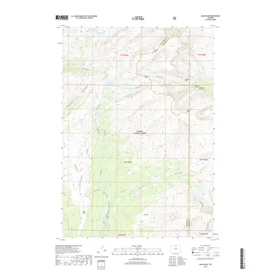
2018 Map of Lake Helen
USGS Topo · Published 2018About this map
Bighorn National Forest defines this high-altitude landscape along the border of Big Horn and Johnson counties. The area is a network of alpine hydrology, where headwaters like W Tensleep Creek and North Clear Creek originate from dozens of glacial basins. Notable peaks such as Bomber Mountain and Mather Peaks loom over a series of high-elevation water bodies, including Lake Helen, Mistymoon Lake, and the Lost Twin Lakes.
Find a feature on this map
40 named features on this map. Tap any name to fly to it.
Don’t see what you’re looking for? This feature index may not catch every label — zoom into the map to look around manually.
Map Details
Editions of this 2018 Lake Helen Map
This is the sole edition of this map. No revisions or reprints were ever made.
Other maps of this area

1899 · Cloud peak
USGS Topo · 1:125,000

1901 · Cloud Peak
USGS Topo · 1:125,000

1955 · Sheridan
USGS Topo · 1:250,000

1958 · Sheridan
USGS Topo · 1:250,000

1960 · Shell Lake
USGS Topo · 1:24,000

1960 · Lake Solitude
USGS Topo · 1:24,000

1962 · Sheridan
USGS Topo · 1:250,000

1967 · Brokenback Narrows
USGS Topo · 1:24,000
1967 · Willow Park Reservoir
USGS Topo · 1:24,000
1967 · Meadowlark Lake
USGS Topo · 1:24,000