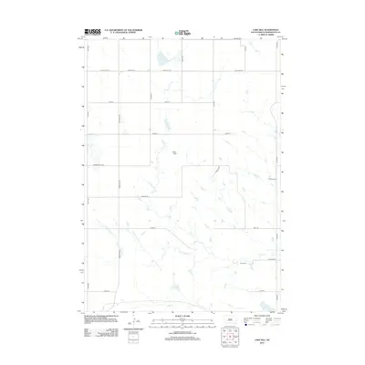
2012 Map of Lake Hill
USGS Topo · Published 2012About this map
Lake Hill rises as a prominent landmark in this Pennington County landscape, where the drainage networks of the western plains define the settlement patterns. The area is characterized by several intermittent watercourses, including Deep Cr, Elm Cr, and the winding Cottonwood Cr, which serve as natural anchors for the region's agricultural operations. Notable ranching holdings like the Hoffman Ranch and Trask Ranch are situated along the eastern section, connected by a network of rural routes such as Paulsen Rd and Wolf Rd. This 2012 survey illustrates a modern prairie environment where isolated water bodies like Shearer Lake and Lake Cr provide essential resources in an otherwise arid expanse. The road grid, featuring Creighton Rd and Kelly Hill Rd, follows the section lines typical of the Great Plains, providing a clear view of the sparse but resilient rural infrastructure.
Find a feature on this map
26 named features on this map. Tap any name to fly to it.
Don’t see what you’re looking for? This feature index may not catch every label — zoom into the map to look around manually.
Map Details
Editions of this 2012 Lake Hill Map
This is the sole edition of this map. No revisions or reprints were ever made.
Other maps of this area

1953 · Rapid City
USGS Topo · 1:250,000

1954 · Wasta NE
USGS Topo · 1:24,000

1954 · Wasta SE
USGS Topo · 1:24,000

1955 · Hot Springs
USGS Topo · 1:250,000

1957 · Rapid City
USGS Topo · 1:250,000

1960 · Quinn Table NE
USGS Topo · 1:24,000

1960 · Wall
USGS Topo · 1:24,000
1961 · Wall NE
USGS Topo · 1:24,000

1981 · Wall
USGS Topo · 1:100,000
1983 · Horse Tooth
USGS Topo · 1:24,000