
1954 Map of Wasta SE
USGS Topo · Published 1956About this map
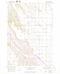
Chicago and North Western tracks trace a diagonal path through this 1954 Pennington County landscape, following the course of Bull Creek toward the northwest. The terrain is defined by the stark transition between the elevated Lake Flat and the deeply eroded breaks of Cedar Canyon. This survey captures the rural infrastructure of the mid-1950s, highlighting the placement of local centers of learning such as Cedar Butte Sch and Pennington Square Sch, which served the ranching families scattered across the Wasta region. The topography is anchored by the prominent Cedar Butte, a high point overlooking a complex network of draws and windmills that reveal the era's reliance on groundwater and rail transportation for prairie survival.
Find a feature on this map
9 named features on this map. Tap any name to fly to it.
Don’t see what you’re looking for? This feature index may not catch every label — zoom into the map to look around manually.
Map Details
Editions of this 1954 Wasta SE Map
2 editions found
Other maps of this area

1953 · Rapid City
USGS Topo · 1:250,000

1954 · Wasta NE
USGS Topo · 1:24,000

1954 · Wasta
USGS Topo · 1:24,000

1954 · Wasta NW
USGS Topo · 1:24,000

1954 · Quinn Table
USGS Topo · 1:24,000

1955 · Hot Springs
USGS Topo · 1:250,000

1957 · Rapid City
USGS Topo · 1:250,000

1960 · Quinn Table NE
USGS Topo · 1:24,000

1960 · Wall
USGS Topo · 1:24,000

1981 · Wall
USGS Topo · 1:100,000