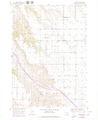
1954 Map of Wasta SE
USGS Topo · Published 1979About this map
Cedar Butte rises above the surrounding plateau in this 1954 topographic record of South Dakota's western plains, part of the Missouri River Basin development program. The landscape is characterized by the expansive Lake Flat and the deep incisions of Cedar Canyon, illustrating the erosional patterns of the local drainage systems. The survey captures a network of rural education, identifying Cedar Butte Sch and Pennington Square Sch, which served the scattered ranching community. The Chicago and North Western railroad provides the primary industrial spine through the territory, running alongside Bull Creek as it navigates the terrain. Notable for its depiction of vital water infrastructure in a semi-arid region, the map marks several Windmill locations essential for cattle ranching during the mid-20th century.
Find a feature on this map
10 named features on this map. Tap any name to fly to it.
Don’t see what you’re looking for? This feature index may not catch every label — zoom into the map to look around manually.
Map Details
Editions of this 1954 Wasta SE Map
2 editions found
Other maps of this area

1953 · Rapid City
USGS Topo · 1:250,000

1954 · Wasta NE
USGS Topo · 1:24,000

1954 · Wasta SE
USGS Topo · 1:24,000

1954 · Wasta
USGS Topo · 1:24,000

1954 · Wasta NW
USGS Topo · 1:24,000

1954 · Quinn Table
USGS Topo · 1:24,000

1955 · Hot Springs
USGS Topo · 1:250,000

1957 · Rapid City
USGS Topo · 1:250,000

1960 · Quinn Table NE
USGS Topo · 1:24,000

1960 · Wall
USGS Topo · 1:24,000