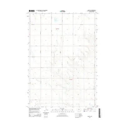
2015 Map of Lake Hill
USGS Topo · Published 2015About this map
Lake Hill rises as the central topographic landmark in this section of Pennington County, presiding over a landscape defined by intermittent watercourses and a strict section-line road grid. The hydrology of the area is dominated by the seasonal drainage patterns of Cottonwood Cr and Lake Cr, which carve shallow relief through the plains. The presence of Shearer Lake to the north and the convergence of Deep Cr and Elm Cr in the northeast corner suggest a terrain managed for cattle and agriculture. This 2015 survey reveals a sparse, high-plains settlement pattern where movement is dictated by a network of rural routes including Creighton Rd and the Quinn-Pedro Rd. Local history is embedded in the family-named infrastructure, such as Sawvell Rd, Kelly Hill Rd, and Paulsen Rd, indicating the persistent legacy of homesteading and ranching families in the Wall vicinity.
Find a feature on this map
27 named features on this map. Tap any name to fly to it.
Don’t see what you’re looking for? This feature index may not catch every label — zoom into the map to look around manually.
Map Details
Editions of this 2015 Lake Hill Map
This is the sole edition of this map. No revisions or reprints were ever made.
Other maps of this area

1953 · Rapid City
USGS Topo · 1:250,000

1954 · Wasta NE
USGS Topo · 1:24,000

1954 · Wasta SE
USGS Topo · 1:24,000

1955 · Hot Springs
USGS Topo · 1:250,000

1957 · Rapid City
USGS Topo · 1:250,000

1960 · Quinn Table NE
USGS Topo · 1:24,000

1960 · Wall
USGS Topo · 1:24,000
1961 · Wall NE
USGS Topo · 1:24,000

1981 · Wall
USGS Topo · 1:100,000
1983 · Horse Tooth
USGS Topo · 1:24,000