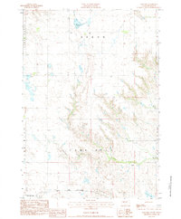
1983 Map of Lake Hill
USGS Topo · Published 1984About this map
Lake Hill and the surrounding Pennington County landscape are defined by a network of drainage systems and isolated ranching outposts recorded in this 1983 survey. The rugged topography is etched by the courses of Lake Hill Creek and Cottonwood Creek, which flow toward the southern edge of the quadrangle. Human presence is concentrated at the Trask Ranch and Hoffman Ranch, representing the enduring pastoral economy of the South Dakota plains. To the north, Shearer Lake provides a rare perennial water source in an area of complex terrain including the Huron and Cedar Butte regions. Near the southern boundary, the Chicago and North Western rail line cuts across the landscape, marking the vital transportation corridor that linked these remote rangelands to larger markets. Further engineering of the land is visible at Quinn Dam, illustrating local efforts to manage water resources for livestock and agriculture in this arid environment.
Find a feature on this map
12 named features on this map. Tap any name to fly to it.
Don’t see what you’re looking for? This feature index may not catch every label — zoom into the map to look around manually.
Map Details
Editions of this 1983 Lake Hill Map
This is the sole edition of this map. No revisions or reprints were ever made.
Other maps of this area

1953 · Rapid City
USGS Topo · 1:250,000

1954 · Wasta NE
USGS Topo · 1:24,000

1954 · Wasta SE
USGS Topo · 1:24,000

1955 · Hot Springs
USGS Topo · 1:250,000

1957 · Rapid City
USGS Topo · 1:250,000

1960 · Quinn Table NE
USGS Topo · 1:24,000

1960 · Wall
USGS Topo · 1:24,000
1961 · Wall NE
USGS Topo · 1:24,000

1981 · Wall
USGS Topo · 1:100,000
1983 · Horse Tooth
USGS Topo · 1:24,000