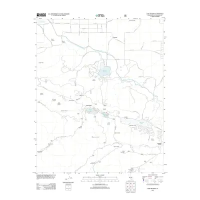
2012 Map of Lake Hughes
USGS Topo · Published 2012About this map
The Governor Edmund G Brown California Aqueduct cuts through this high desert and canyon landscape, illustrating the complex water infrastructure of northern Los Angeles County. Centered on the communities of Lake Hughes and Elizabeth Lake, the map shows a string of small water bodies following the fault line, including Munz Lakes and the Fairmont Reservoir. The presence of the Elizabeth Tunnel and its South Portal indicates the area's role in the historic Los Angeles Aqueduct system. To the north, the settlement of Fairmont sits near the foot of Fairmont Butte, while the southern terrain rises toward Grass Mountain. Notable local landmarks range from the Canyon Meadows Church Camp and San Francisquito Campground to institutional sites like Los Angeles County Camp 7, reflecting a mix of recreation and municipal utility in the Antelope Valley foothills.
Find a feature on this map
85 named features on this map. Tap any name to fly to it.
Don’t see what you’re looking for? This feature index may not catch every label — zoom into the map to look around manually.
Map Details
Editions of this 2012 Lake Hughes Map
This is the sole edition of this map. No revisions or reprints were ever made.
Other maps of this area

1903 · Tejon
USGS Topo · 1:125,000

1915 · Elizabeth Lake
USGS Topo · 1:125,000

1917 · Elizabeth Lake
USGS Topo · 1:125,000

1931 · Warm Spring
USGS Topo · 1:24,000

1931 · Little Buttes
USGS Topo · 1:24,000

1932 · Lake
USGS Topo · 1:24,000

1932 · Hughes Lake
USGS Topo · 1:24,000

1932 · Fairmont
USGS Topo · 1:24,000

1933 · Manzana
USGS Topo · 1:24,000

1934 · Little Buttes
USGS Topo · 1:24,000