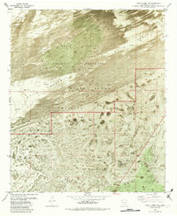
1982 Map of Lake Lucero NE
USGS Topo · Published 1982About this map
White Sands dominates this 1982 orthophoto quadrangle, where the shifting landscape of gypsum dunes meets the high-tech requirements of the Cold War era. This particular view highlights the transition from the protected terrain of White Sands National Monument to the restricted territory of the White Sands Missile Range. The orthophotomosaic base provides a photographic texture of the basin floor, revealing the precise patterns of dunes and sparse desert vegetation. In the southern reaches of the map, a remote Landing Strip and a small water catchment known as Antelope Tank suggest the dual nature of this land as both a wilderness and a functional military testing ground. The boundary between the national monument and the missile range is clearly delineated, showing how public preservation and national defense shared this unique New Mexico environment.
Find a feature on this map
7 named features on this map. Tap any name to fly to it.
Don’t see what you’re looking for? This feature index may not catch every label — zoom into the map to look around manually.
Map Details
Editions of this 1982 Lake Lucero NE Map
This is the sole edition of this map. No revisions or reprints were ever made.
Other maps of this area

1916 · Point Of Sands
USGS Topo · 1:125,000

1947 · Point Of Sands 2
USGS Topo · 1:62,500

1947 · Lake Lucero
USGS Topo · 1:62,500

1948 · Tres Hermanos
USGS Topo · 1:62,500

1948 · Holloman
USGS Topo · 1:62,500

1948 · Lake Lucero
USGS Topo · 1:24,000

1948 · Lake Lucero SW
USGS Topo · 1:24,000

1948 · Lake Lucero SE
USGS Topo · 1:24,000
1950 · Lake Lucero
USGS Topo · 1:24,000
1950 · Lake Lucero SW
USGS Topo · 1:24,000