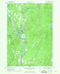
1968 Map of Lake Luzerne
USGS Topo · Published 1970About this map
The Hudson River carves a deep valley through the southeastern edge of Adirondack State Park, serving as the primary corridor for both the Delaware and Hudson railroad and local settlement. The village of Hadley sits at the confluence with the Sacandaga River, directly across from the town of Lake Luzerne. This 1968 survey reveals a landscape of high summits and seasonal water bodies, where the Luzerne Mountains dominate the east and West Mountian rises toward the south. Local history is recorded in several small cemeteries, including the Old Methodist Cem and Leavens Cem, while industry is represented by numerous Gravel Pits and the active rail lines. The terrain transitions from the open waters of Fourth Lake and Lake Vanare in the north to the sprawling Ninemile Swamp in the south, illustrating the complex drainage patterns of the upper Hudson region.
Find a feature on this map
86 named features on this map. Tap any name to fly to it.
Don’t see what you’re looking for? This feature index may not catch every label — zoom into the map to look around manually.
Map Details
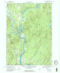
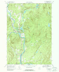
Editions of this 1968 Lake Luzerne Map
3 editions found
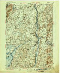
Other maps of this area

1895 · Glens Falls
USGS Topo · 1:62,500

1897 · Glens Falls
USGS Topo · 1:62,500

1900 · Schuylerville
USGS Topo · 1:62,500

1902 · Saratoga
USGS Topo · 1:62,500

1903 · Luzerne
USGS Topo · 1:62,500

1935 · Gansevoort
USGS Topo · 1:24,000

1935 · Corinth
USGS Topo · 1:24,000

1938 · Glens Falls
USGS Topo · 1:62,500
1940 · Schuylerville
USGS Topo · 1:62,500

1942 · Saratoga
USGS Topo · 1:62,500