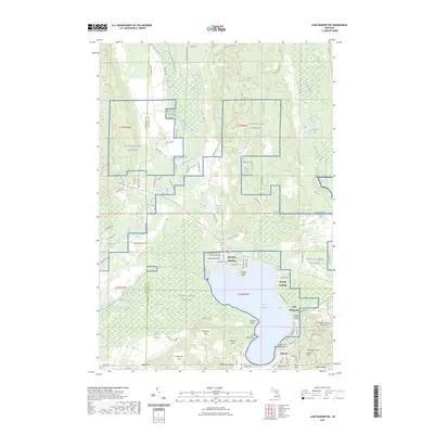
2023 Map of Lake Margrethe
USGS Topo · Published 2023About this map
Lake Margrethe and the expansive NG MTC-H Camp Grayling training grounds define this central Michigan landscape. The lake is a focal point for local geography, featuring established lakeside sites such as Danish Landing and McIntyre Landing. To the south and east, a cluster of named peaks including Hanson Hills, Mount Franklin, and Red Arrow Hill rise above the surrounding terrain, while the United States Government Military Cem sits near the small settlement of Rasmus. The environmental character of the region is preserved through the Kirtlands Warbler WMA and the winding course of the Manistee River, which cuts through the northwestern portion of the map. This area represents a critical intersection of military training facilities and recreational water bodies, where the Portage Creek drainage system links the high ground to the lake basin.
Find a feature on this map
105 named features on this map. Tap any name to fly to it.
Don’t see what you’re looking for? This feature index may not catch every label — zoom into the map to look around manually.
Map Details
Editions of this 2023 Lake Margrethe Map
This is the sole edition of this map. No revisions or reprints were ever made.
Other maps of this area

1949 · Black Creek
USGS Topo · 1:24,000

1949 · Otsego Lake
USGS Topo · 1:62,500

1949 · Fletcher
USGS Topo · 1:62,500

1949 · Grayling
USGS Topo · 1:62,500

1950 · Cote Dame Marie
USGS Topo · 1:24,000

1950 · Fletcher
USGS Topo · 1:24,000

1950 · Lake Margrethe
USGS Topo · 1:24,000

1950 · Grayling
USGS Topo · 1:24,000

1951 · Big Bradford Lake
USGS Topo · 1:24,000

1951 · Grayling
USGS Topo · 1:24,000
Featured Places
- Grayling Charter Township, MI
- Bear Lake Township, MI
- Collens Landing, MI
- Danish Landing, MI
- Lake Margrethe, MI