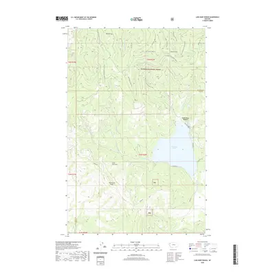
2020 Map of Lake Mary Ronan
USGS Topo · Published 2020About this map
Lake Mary Ronan defines the central basin of this landscape, surrounded by the high elevations of the Salish Mountains and the Hog Heaven Range. Much of the northern terrain is managed as part of the Flathead National Forest, where a network of forest development roads and specialized routes like the Blacktail OHV Trail provide access to the slopes of Blacktail Mtn. The small settlement of Lake Mary Ronan is concentrated along the northeastern shore, served by Lake Mary Ronan Rd and Camp Tuffit Rd. Numerous drainages, including Wild Bill Cr, Truman Cr, and Freeland Cr, carve through the topography, illustrating the complex watershed that feeds the lake. The map also delineates the county line separating Flathead and Lake Counties, marking a significant political boundary amidst the dense forest and mountain ridges.
Find a feature on this map
33 named features on this map. Tap any name to fly to it.
Don’t see what you’re looking for? This feature index may not catch every label — zoom into the map to look around manually.
Map Details
Editions of this 2020 Lake Mary Ronan Map
This is the sole edition of this map. No revisions or reprints were ever made.
Other maps of this area

1920 · Flathead Lake
USGS Topo · 1:125,000

1943 · Kalispell
USGS Topo · 1:125,000

1956 · Wallace
USGS Topo · 1:250,000

1957 · Kalispell
USGS Topo · 1:250,000

1960 · Kalispell
USGS Topo · 1:250,000

1960 · Wallace
USGS Topo · 1:250,000

1961 · Kalispell
USGS Topo · 1:250,000

1962 · Kila
USGS Topo · 1:24,000

1962 · Lion Mountain
USGS Topo · 1:24,000

1964 · Irvine Lookout Tower
USGS Topo · 1:24,000