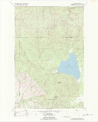
1982 Map of Lake Mary Ronan
USGS Topo · Published 1982About this map
Lake Mary Ronan sits at the heart of this landscape, its western shores defined by the dramatic rise of the Hog Heaven Range. This 1982 revision, based on data from the Bureau of Indian Affairs, details a region where high-altitude ridges like Wild Bill Mountain and Blacktail Mountain overlook a network of seasonal drainages and springs. The map documents the intricate boundary between the Flathead National Forest and the Flathead Indian Reservation, illustrating a complex pattern of land management and natural resource protection. Local infrastructure is represented by a series of specialized routes, including the Burma Road and various pack trails that navigate the steep terrain west of the lake. Toward the southern edge, the small settlement at Cromwell and the open expanse of Big Meadows provide evidence of the scattered rural development and agricultural pockets within the mountain valleys.
Find a feature on this map
23 named features on this map. Tap any name to fly to it.
Don’t see what you’re looking for? This feature index may not catch every label — zoom into the map to look around manually.
Map Details
Editions of this 1982 Lake Mary Ronan Map
This is the sole edition of this map. No revisions or reprints were ever made.
Other maps of this area

1920 · Flathead Lake
USGS Topo · 1:125,000

1943 · Kalispell
USGS Topo · 1:125,000

1956 · Wallace
USGS Topo · 1:250,000

1957 · Kalispell
USGS Topo · 1:250,000

1960 · Kalispell
USGS Topo · 1:250,000

1960 · Wallace
USGS Topo · 1:250,000

1961 · Kalispell
USGS Topo · 1:250,000

1962 · Kila
USGS Topo · 1:24,000

1962 · Lion Mountain
USGS Topo · 1:24,000

1964 · Irvine Lookout Tower
USGS Topo · 1:24,000