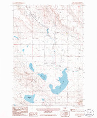
1986 Map of Lake Mason
USGS Topo · Published 1986About this map
The Lake Mason National Wildlife Refuge dominates this Central Montana landscape in Musselshell County. The map details a specialized lacustrine environment where water management features like Dam 3610 and Spillway 3606 regulate the namesake Lake Mason. This 1986 provisional survey illustrates the importance of water storage and wildlife habitat in an arid region, with prominent basins including May Martin Lake, Talbot Lake, and Lake Thom interconnected by seasonal flows from Willow Creek. Beyond the wetlands, the terrain is marked by industrial activity, including several Oil Well sites, Tanks, and a Quarry, reflecting the area's dual role as a conservation zone and a resource extraction landscape. Researchers can trace the precise contours and drainage patterns that define this high-plains refuge system.
Find a feature on this map
13 named features on this map. Tap any name to fly to it.
Don’t see what you’re looking for? This feature index may not catch every label — zoom into the map to look around manually.
Map Details
Editions of this 1986 Lake Mason Map
This is the sole edition of this map. No revisions or reprints were ever made.
Other maps of this area

1954 · Roundup
USGS Topo · 1:250,000

1958 · Roundup
USGS Topo · 1:250,000

1979 · Roundup
USGS Topo · 1:100,000

1979 · Timber Buttes South
USGS Topo · 1:24,000

1979 · Horsethief Creek
USGS Topo · 1:24,000

1979 · Roundup
USGS Topo · 1:24,000

1986 · Lake Mason SE
USGS Topo · 1:24,000

1986 · Pender Coulee
USGS Topo · 1:24,000

1986 · Lake Mason NE
USGS Topo · 1:24,000

1986 · Lake Mason NW
USGS Topo · 1:24,000