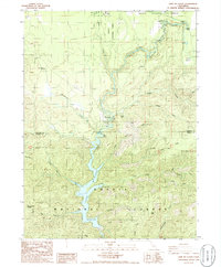
1986 Map of Lake McCloud
USGS Topo · Published 1986About this map
Lake McCloud and the winding McCloud River dominate this mid-1980s landscape within the Shasta National Forest. The geography is defined by a series of dramatic river features, including Lower Falls, Middle Falls, and Upper Falls near the Fowlers Campground. The man-made hydrology of the area is evident at Lakin Dam and the northern reaches of the lake near The Bend, where a boat ramp and various gauging stations monitor the flow.
Find a feature on this map
50 named features on this map. Tap any name to fly to it.
Don’t see what you’re looking for? This feature index may not catch every label — zoom into the map to look around manually.
Map Details
Editions of this 1986 Lake McCloud Map
2 editions found
Other maps of this area

1886 · Modoc Lava Bed
USGS Topo · 1:250,000

1886 · Shasta
USGS Topo · 1:250,000

1892 · Modoc Lava-Bed
USGS Topo · 1:250,000

1894 · Shasta
USGS Topo · 1:250,000

1932 · Bartle
USGS Topo · 1:96,000

1935 · Dunsmuir
USGS Topo · 1:125,000

1939 · Bartle
USGS Topo · 1:125,000

1948 · Weed
USGS Topo · 1:250,000

1950 · Weed
USGS Topo · 1:250,000

1954 · Shoeinhorse Mountain
USGS Topo · 1:62,500