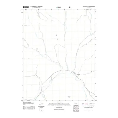
2011 Map of Lake Mountain NE
USGS Topo · Published 2011About this map
Saguache Creek winds through the southern reaches of this Colorado landscape, defining a drainage basin punctuated by numerous gulches and draws. The high-altitude terrain is marked by the presence of Indian Park to the north and Houghland Hill near the southern boundary, reflecting the varied topography of Saguache County. A network of rural routes, including County Rd 38 and County Rd CC 36, provides access to the interior where Jacks Creek and Middle Creek converge toward the main valley floor.
Find a feature on this map
24 named features on this map. Tap any name to fly to it.
Don’t see what you’re looking for? This feature index may not catch every label — zoom into the map to look around manually.
Map Details
Editions of this 2011 Lake Mountain NE Map
This is the sole edition of this map. No revisions or reprints were ever made.
Other maps of this area

1956 · Montrose
USGS Topo · 1:250,000

1959 · Montrose
USGS Topo · 1:250,000

1959 · Bonanza
USGS Topo · 1:62,500

1960 · Montrose
USGS Topo · 1:250,000

1967 · Sargents Mesa
USGS Topo · 1:24,000
1967 · Laughlin Gulch
USGS Topo · 1:24,000

1967 · Trickle Mountain
USGS Topo · 1:24,000

1967 · Lake Mountain NE
USGS Topo · 1:24,000
1967 · Lake Mountain NE
USGS Topo · 1:24,000

1967 · Chester
USGS Topo · 1:24,000