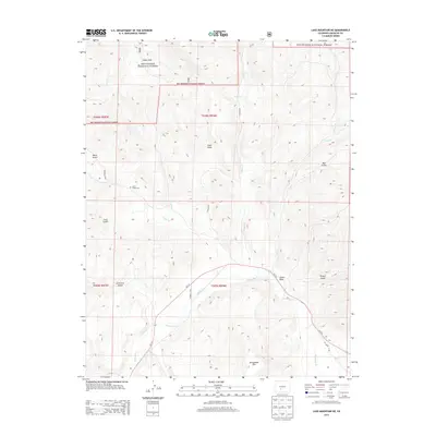
2013 Map of Lake Mountain NE
USGS Topo · Published 2013About this map
Rio Grande National Forest dominates the northern landscape of this Saguache County terrain, where the high mountain meadows of Indian Park transition into a series of deeply carved drainages. The local geography is defined by a network of seasonal and perennial waters, including Bear Cr, Middle Cr, and the prominent Saguache Cr, which winds through the southern portion of the quadrangle. For those researching local burial sites or family history, the Jacks Creek Cem is situated near Jacks Cr, north of Co-114. The map reveals a rugged land use pattern of forest service roads and primitive trails such as Ward Gulch Rd, connecting numerous named canyons like Chico Gulch and Mill Gulch. Prominent landforms such as Castle Rock and Houghland Hill provide distinct navigational benchmarks within this high-altitude Colorado environment.
Find a feature on this map
28 named features on this map. Tap any name to fly to it.
Don’t see what you’re looking for? This feature index may not catch every label — zoom into the map to look around manually.
Map Details
Editions of this 2013 Lake Mountain NE Map
This is the sole edition of this map. No revisions or reprints were ever made.
Other maps of this area

1956 · Montrose
USGS Topo · 1:250,000

1959 · Montrose
USGS Topo · 1:250,000

1959 · Bonanza
USGS Topo · 1:62,500

1960 · Montrose
USGS Topo · 1:250,000

1967 · Sargents Mesa
USGS Topo · 1:24,000
1967 · Laughlin Gulch
USGS Topo · 1:24,000

1967 · Trickle Mountain
USGS Topo · 1:24,000

1967 · Lake Mountain NE
USGS Topo · 1:24,000
1967 · Lake Mountain NE
USGS Topo · 1:24,000

1967 · Chester
USGS Topo · 1:24,000