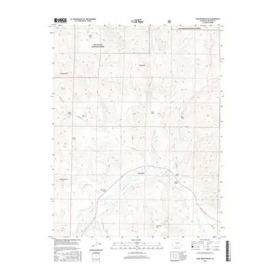
2016 Map of Lake Mountain NE
USGS Topo · Published 2016About this map
Rio Grande National Forest lands dominate this high-altitude landscape in Saguache County, where a complex network of canyons and gulches defines the drainage pattern toward Saguache Cr. The 2016 survey captures a region where narrow access roads like Ward Gulch Rd and Co Rd 38 EE wind through the terrain, connecting isolated landmarks and small family burial sites such as Jacks Creek Cem.
Find a feature on this map
29 named features on this map. Tap any name to fly to it.
Don’t see what you’re looking for? This feature index may not catch every label — zoom into the map to look around manually.
Map Details
Editions of this 2016 Lake Mountain NE Map
This is the sole edition of this map. No revisions or reprints were ever made.
Other maps of this area

1956 · Montrose
USGS Topo · 1:250,000

1959 · Montrose
USGS Topo · 1:250,000

1959 · Bonanza
USGS Topo · 1:62,500

1960 · Montrose
USGS Topo · 1:250,000

1967 · Sargents Mesa
USGS Topo · 1:24,000
1967 · Laughlin Gulch
USGS Topo · 1:24,000

1967 · Trickle Mountain
USGS Topo · 1:24,000

1967 · Lake Mountain NE
USGS Topo · 1:24,000
1967 · Lake Mountain NE
USGS Topo · 1:24,000

1967 · Chester
USGS Topo · 1:24,000