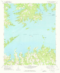
1971 Map of Lake Murray East
USGS Topo · Published 1973About this map
Lake Murray dominates the landscape of this 1970s survey, its waters reaching deep into the rolling Piedmont terrain of Lexington and Richland counties. The reservoir shoreline is defined by numerous inlets and the prominent silhouettes of Counts Island, Shull Island, and Bundrick Island. On the southern shores, rural life is anchored by a network of local congregations including St Johns Ch and St Peters Ch, while the settlement of Providence sits near the headwaters of Eighteenmile Creek. The map documents a rural transition as former farmland and creek valleys like Twentymile Creek and Beaverdam Creek meet the expanding recreational and residential influence of the lake. Local historians can trace the placement of numerous small family or community cemeteries scattered throughout the wooded hills, preserving a record of the area's older agricultural footprint before the modern development of the lakefront.
Find a feature on this map
21 named features on this map. Tap any name to fly to it.
Don’t see what you’re looking for? This feature index may not catch every label — zoom into the map to look around manually.
Map Details
Editions of this 1971 Lake Murray East Map
This is the sole edition of this map. No revisions or reprints were ever made.
Other maps of this area

1904 · Columbia
USGS Topo · 1:125,000

1941 · Spartanburg
USGS Topo · 1:250,000

1944 · Gilbert
USGS Topo · 1:62,500

1944 · Edmund
USGS Topo · 1:62,500

1946 · Irmo
USGS Topo · 1:24,000

1947 · Richtex
USGS Topo · 1:24,000

1948 · Irmo
USGS Topo · 1:24,000

1949 · Richtex
USGS Topo · 1:24,000

1953 · Spartanburg
USGS Topo · 1:250,000

1954 · Augusta
USGS Topo · 1:250,000