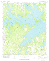
1971 Map of Lake Murray West
USGS Topo · Published 1974About this map
Lake Murray dominates this 1971 landscape at an elevation of 360 feet, where the rising waters have created a complex shoreline of deep coves and numerous islands. The submerged path of the Saluda River continues to define the boundary between Lexington and Newberry counties, while the surrounding hills are dotted with established rural communities and small crossroads. Significant landmarks such as Dreher Island and the Landing Strip near the northern shore suggest the area's transition toward recreational and aviation uses during the early 1970s.
Find a feature on this map
33 named features on this map. Tap any name to fly to it.
Don’t see what you’re looking for? This feature index may not catch every label — zoom into the map to look around manually.
Map Details
Editions of this 1971 Lake Murray West Map
This is the sole edition of this map. No revisions or reprints were ever made.
Other maps of this area

1904 · Columbia
USGS Topo · 1:125,000

1941 · Spartanburg
USGS Topo · 1:250,000

1944 · Gilbert
USGS Topo · 1:62,500

1953 · Spartanburg
USGS Topo · 1:250,000

1954 · Augusta
USGS Topo · 1:250,000

1957 · Augusta
USGS Topo · 1:250,000

1958 · Augusta
USGS Topo · 1:250,000

1960 · Spartanburg
USGS Topo · 1:250,000

1961 · Augusta
USGS Topo · 1:250,000

1962 · Augusta
USGS Topo · 1:250,000