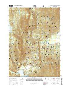
2014 Map of Lake of the Woods North
USGS Topo · Published 2014About this map
Winema National Forest dominates this landscape in the southern Oregon Cascades, defined by a complex network of forest development roads and volcanic terrain. The northern shoreline of Lake of the Woods serves as a primary reference point in the south, while the hydrological system includes the Cascade Canal and numerous high-elevation water bodies like Fourmile Lake, Budger Lake, and Woodpecker Lake. Notable topographic landmarks such as Rye Spur and Pearce Point overlook the drainages of Billie Cr and Fourmile Cr. Industrial and infrastructure elements are present through the Fourmile Quarry and a prominent powerline corridor that cuts through the forest south of Fourmile Flat. The map reveals the intricate management of this timber and recreation land, documented through various Forest Service routes including Nat For Dev Rd 3651 and Nat For Dev Rd 3458.
Find a feature on this map
41 named features on this map. Tap any name to fly to it.
Don’t see what you’re looking for? This feature index may not catch every label — zoom into the map to look around manually.
Map Details
Editions of this 2014 Lake of the Woods North Map
This is the sole edition of this map. No revisions or reprints were ever made.
Other maps of this area

1891 · Ashland
USGS Topo · 1:250,000

1893 · Ashland
USGS Topo · 1:250,000

1897 · Ashland
USGS Topo · 1:250,000

1955 · Lake O' Woods
USGS Topo · 1:62,500

1955 · Rustler Peak
USGS Topo · 1:62,500

1955 · Mt. Mc Loughlin
USGS Topo · 1:62,500

1955 · Pelican Butte
USGS Topo · 1:62,500

1955 · Medford
USGS Topo · 1:250,000

1957 · Medford
USGS Topo · 1:250,000

1958 · Medford
USGS Topo · 1:250,000