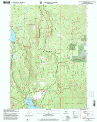
1998 Map of Lake of The Woods North
USGS Topo · Published 2000About this map
Winema National Forest serves as the backdrop for this late 20th-century landscape, where recreation and resource management intersect in the High Cascades. The map highlights the developed southern shoreline of Lake of the Woods, featuring the Lake of the Woods Resort, Camp McLoughlin, and established campgrounds at Aspen Point and Rainbow Bay. This cluster of activity contrasts with the protected wilderness boundaries to the north and south, providing a detailed look at the infrastructure required to maintain this high-elevation retreat, including a State Highway Maintenance Sta and a Fire Guard Station.
Find a feature on this map
49 named features on this map. Tap any name to fly to it.
Don’t see what you’re looking for? This feature index may not catch every label — zoom into the map to look around manually.
Map Details
Editions of this 1998 Lake of The Woods North Map
This is the sole edition of this map. No revisions or reprints were ever made.
Other maps of this area

1891 · Ashland
USGS Topo · 1:250,000

1893 · Ashland
USGS Topo · 1:250,000

1897 · Ashland
USGS Topo · 1:250,000

1955 · Lake O' Woods
USGS Topo · 1:62,500

1955 · Rustler Peak
USGS Topo · 1:62,500

1955 · Mt. Mc Loughlin
USGS Topo · 1:62,500

1955 · Pelican Butte
USGS Topo · 1:62,500

1955 · Medford
USGS Topo · 1:250,000

1957 · Medford
USGS Topo · 1:250,000

1958 · Medford
USGS Topo · 1:250,000