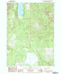
1985 Map of Lake of The Woods South
USGS Topo · Published 1985About this map
Lake of The Woods and Buck Lake anchor this 1980s landscape at the boundary of the Rogue River National Forest and Winema National Forest. The map documents a seasonal recreation and conservation hub, featuring established sites such as Camp Esther Applegate, Low Echo Camp, and the Sunset Campground. These landings and camps reflect the long-standing use of the high-altitude lakes for summer activity and youth education.
Find a feature on this map
29 named features on this map. Tap any name to fly to it.
Don’t see what you’re looking for? This feature index may not catch every label — zoom into the map to look around manually.
Map Details
Editions of this 1985 Lake of The Woods South Map
This is the sole edition of this map. No revisions or reprints were ever made.
Other maps of this area

1891 · Ashland
USGS Topo · 1:250,000

1893 · Ashland
USGS Topo · 1:250,000

1897 · Ashland
USGS Topo · 1:250,000

1955 · Lake O' Woods
USGS Topo · 1:62,500

1955 · Surveyor Mtn
USGS Topo · 1:62,500

1955 · Hyatt Reservoir
USGS Topo · 1:62,500

1955 · Mt. Mc Loughlin
USGS Topo · 1:62,500

1955 · Medford
USGS Topo · 1:250,000

1957 · Medford
USGS Topo · 1:250,000

1958 · Medford
USGS Topo · 1:250,000