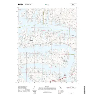
2017 Map of Lake Ozark
USGS Topo · Published 2017About this map
Lake of the Ozarks dominates this landscape, its intricate shoreline creating a complex network of coves and points that defined the mid-century development of the region. The map showcases the established resort and residential character of towns like Osage Beach and the Village of Four Seasons, where winding roads such as Timber Village Dr and Echo Valley Rd follow the local topography. Away from the water’s edge, a deeper layer of history is revealed through family-named landmarks and cemeteries, including Riley Lamb Cem and Stevens Banner Cem. These small burial grounds, along with features like Carrot Bluff and Baydy Peak, provide a geographic record of the families who inhabited the ridges of Camden Co and Miller Co long before the major tourism expansion. Three engineered reservoirs, including Burton Duenke Number 1 Reservoir, indicate the managed water systems supporting the area's growth.
Find a feature on this map
280 named features on this map. Tap any name to fly to it.
Don’t see what you’re looking for? This feature index may not catch every label — zoom into the map to look around manually.
Map Details
Editions of this 2017 Lake Ozark Map
This is the sole edition of this map. No revisions or reprints were ever made.
Other maps of this area

1888 · Versailles
USGS Topo · 1:125,000

1893 · Versailles
USGS Topo · 1:125,000

1904 · Eldon
USGS Topo · 1:62,500

1904 · Gravois Mills
USGS Topo · 1:62,500

1932 · Versailles No 4
USGS Topo · 1:48,000

1934 · Camdenton
USGS Topo · 1:24,000

1934 · Purvis
USGS Topo · 1:24,000

1934 · Toronto
USGS Topo · 1:24,000

1934 · Lake Ozark
USGS Topo · 1:24,000

1934 · Bagnell
USGS Topo · 1:24,000