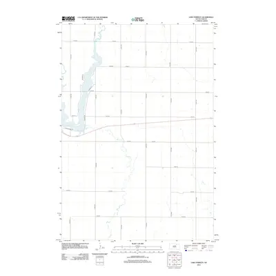
2012 Map of Lake Parmley
USGS Topo · Published 2012About this map
Snake Cr meanders southward through the center of this landscape, its path defining the rural character of Brown County in the early twenty-first century. The waterway flows into Lake Parmley in the west-central portion of the quadrangle, where a small cluster of residential roads suggests a lakeside community. Streets such as S Sunset Dr, Lucinda Ln, and Nesbitt Dr provide access to the shoreline, while Southshore Dr skirts the southern edge of the water. Outside of this localized development, the area is defined by a rigorous section-line road grid, with numbered avenues like 372nd Ave and 378th Ave crossing numbered streets from 131st St down to 138th St, illustrating the enduring structure of the Great Plains survey system.
Find a feature on this map
20 named features on this map. Tap any name to fly to it.
Don’t see what you’re looking for? This feature index may not catch every label — zoom into the map to look around manually.
Map Details
Editions of this 2012 Lake Parmley Map
This is the sole edition of this map. No revisions or reprints were ever made.
Other maps of this area

1899 · Ellendale
USGS Topo · 1:125,000

1899 · Northville
USGS Topo · 1:125,000

1954 · Aberdeen
USGS Topo · 1:250,000

1956 · Aberdeen
USGS Topo · 1:250,000

1960 · Aberdeen West
USGS Topo · 1:24,000

1960 · Rudolph
USGS Topo · 1:24,000

1970 · Lake Parmley
USGS Topo · 1:24,000
1970 · Richmond
USGS Topo · 1:24,000
1970 · Lake Parmley SW
USGS Topo · 1:24,000

1970 · Wetonka South
USGS Topo · 1:24,000