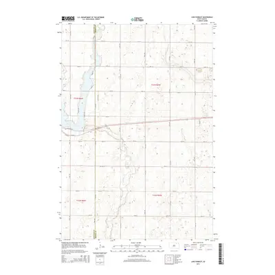
2015 Map of Lake Parmley
USGS Topo · Published 2015About this map
Lake Parmley and the winding course of Snake Creek define this rural landscape on the border of Edmunds and Brown counties. The map illustrates a transitional period of development around the lake, where traditional section-line roads like 131st St and 135th St meet newer residential clusters. Evidence of localized planning appears in the street names lining the shore, including Sunrise Dr, Nesbitt Dr, and Southshore Dr. The surrounding prairie remains largely dominated by the Public Land Survey System grid, which is deeply etched into the township infrastructure. This topography provides a clear look at how water resources and recreation have influenced the modern settlement patterns in this part of South Dakota, contrasting the open range with concentrated lakeside tracts such as those along Lucinda Ln and Edgar Rd.
Find a feature on this map
23 named features on this map. Tap any name to fly to it.
Don’t see what you’re looking for? This feature index may not catch every label — zoom into the map to look around manually.
Map Details
Editions of this 2015 Lake Parmley Map
This is the sole edition of this map. No revisions or reprints were ever made.
Other maps of this area

1899 · Ellendale
USGS Topo · 1:125,000

1899 · Northville
USGS Topo · 1:125,000

1954 · Aberdeen
USGS Topo · 1:250,000

1956 · Aberdeen
USGS Topo · 1:250,000

1960 · Aberdeen West
USGS Topo · 1:24,000

1960 · Rudolph
USGS Topo · 1:24,000

1970 · Lake Parmley
USGS Topo · 1:24,000
1970 · Richmond
USGS Topo · 1:24,000
1970 · Lake Parmley SW
USGS Topo · 1:24,000

1970 · Wetonka South
USGS Topo · 1:24,000