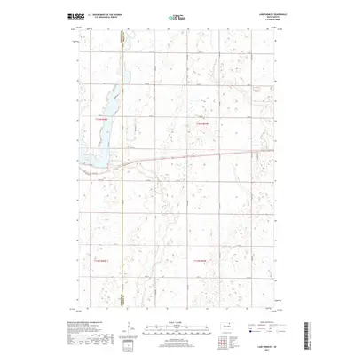
2017 Map of Lake Parmley
USGS Topo · Published 2017About this map
Lake Parmley and the winding course of Snake Creek dominate this landscape along the border of Edmunds and Brown Counties. The terrain is characterized by numerous small wetlands and glacial potholes typical of the region's prairie coteau. A network of section-line roads like 131st St and 375th Ave grids the agricultural land, while more irregular residential lanes like Sunrise Dr, S Shore Dr, and S Sunset Dr cluster around the lake's western edge. This pattern reflects the area's dual nature as both productive farmland and a recreational destination. Researchers can trace the specific development of the lakeshore and the exact alignment of local infrastructure like Co Rd 2 and Edgar Rd as they existed in the early twenty-first century.
Find a feature on this map
33 named features on this map. Tap any name to fly to it.
Don’t see what you’re looking for? This feature index may not catch every label — zoom into the map to look around manually.
Map Details
Editions of this 2017 Lake Parmley Map
This is the sole edition of this map. No revisions or reprints were ever made.
Other maps of this area

1899 · Ellendale
USGS Topo · 1:125,000

1899 · Northville
USGS Topo · 1:125,000

1954 · Aberdeen
USGS Topo · 1:250,000

1956 · Aberdeen
USGS Topo · 1:250,000

1960 · Aberdeen West
USGS Topo · 1:24,000

1960 · Rudolph
USGS Topo · 1:24,000

1970 · Lake Parmley
USGS Topo · 1:24,000
1970 · Richmond
USGS Topo · 1:24,000
1970 · Lake Parmley SW
USGS Topo · 1:24,000

1970 · Wetonka South
USGS Topo · 1:24,000