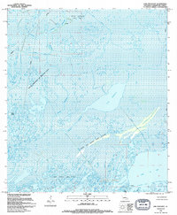
1994 Map of Lake Penchant
USGS Topo · Published 1994About this map
Lake Penchant dominates this coastal Louisiana landscape, a watery expanse in a region defined by complex bayous and industrial energy extraction. The intersection of the state's natural hydrology and its oil and gas economy is visible throughout the quadrangle, with the Bayou Penchant Oil and Gas Field and Lake De Cade Gas Field sprawling across the marshlands. A network of man-made features like the Muth Canal, Florence Canal, and various pipelines cut through the wetlands, illustrating how the environment has been engineered to facilitate resource recovery.
Find a feature on this map
25 named features on this map. Tap any name to fly to it.
Don’t see what you’re looking for? This feature index may not catch every label — zoom into the map to look around manually.
Map Details
Editions of this 1994 Lake Penchant Map
This is the sole edition of this map. No revisions or reprints were ever made.
Other maps of this area

1892 · Gibson
USGS Topo · 1:62,500

1894 · Bayou De Large
USGS Topo · 1:62,500

1897 · Gibson
USGS Topo · 1:62,500

1932 · Lake Decade
USGS Topo · 1:62,500

1935 · Theriot
USGS Topo · 1:31,680

1935 · Morgan City
USGS Topo · 1:62,500

1935 · Lake Mechant
USGS Topo · 1:31,680

1935 · Lake Penchant
USGS Topo · 1:31,680

1939 · Gibson
USGS Topo · 1:62,500

1940 · Bayou Du Large
USGS Topo · 1:62,500