
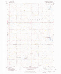
1968 Map of Lake Preston NE
USGS Topo · Published 1970About this map
Glacial depressions and agricultural field lines define the landscape of Kingsbury County in the late 1960s, a terrain shaped by the townships of Hartland, Badger, Baker, and Denver. The southern edge of the survey is dominated by the northern reaches of Lake Preston, while the surrounding prairie is dotted with localized landmarks of the Norwegian Lutheran heritage common to this region. Several rural congregations and their associated burial grounds serve as anchors for the local community, including Bethania Ch and Bethania Cem in the northwest, and North Preston Ch near the center of the sheet. The transport of goods during this era relied on the Chicago and North Western railroad corridor along the southern margin, while local industry is represented by scattered Gravel Pits used for road maintenance. This map preserves the exact placement of family-named sites like Hinderlie Cem and Odden Cem before modern agricultural consolidation.
Find a feature on this map
13 named features on this map. Tap any name to fly to it.
Don’t see what you’re looking for? This feature index may not catch every label — zoom into the map to look around manually.
Map Details
Editions of this 1968 Lake Preston NE Map
This is the sole edition of this map. No revisions or reprints were ever made.
Other maps of this area

1953 · Watertown
USGS Topo · 1:250,000

1958 · Watertown
USGS Topo · 1:250,000

1968 · Lake Preston East
USGS Topo · 1:24,000

1968 · Lake Preston West
USGS Topo · 1:24,000

1968 · Arlington
USGS Topo · 1:24,000

1968 · Erwin
USGS Topo · 1:24,000

1968 · Badger
USGS Topo · 1:24,000

1969 · Lake Norden
USGS Topo · 1:24,000

1973 · Bryant
USGS Topo · 1:24,000
1973 · Gertson Slough
USGS Topo · 1:24,000