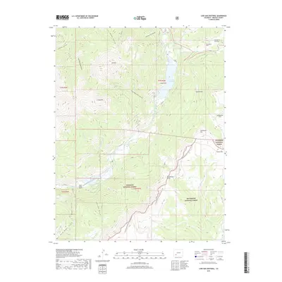
2019 Map of Lake San Cristobal
USGS Topo · Published 2019About this map
Lake San Cristobal dominates the upper portion of this quadrangle, formed by the massive Slumgullion Earthflow which famously dammed the Lake Fork river. This geological instability is further evidenced by the nearby Slumgullion Slide, creating a landscape defined by slow-moving earth and high-altitude water bodies. To the south, the Continental Divide National Scenic Trail winds through the high country along the border of the Gunnison National Forest and Rio Grande National Forest. The map captures a mix of recreational and remote transport infrastructure, from the Castle Lakes Airport near Castle Lakes to the rugged routes of Co RD 30 and 149. Distinctive peaks and mesas such as Red Mtn, Seventyone Mtn, and Jarosa Mesa provide sharp vertical relief against the creek-carved basins of Wager Gulch and Cascade Gulch.
Find a feature on this map
42 named features on this map. Tap any name to fly to it.
Don’t see what you’re looking for? This feature index may not catch every label — zoom into the map to look around manually.
Map Details
Editions of this 2019 Lake San Cristobal Map
This is the sole edition of this map. No revisions or reprints were ever made.
Other maps of this area

1903 · Lake City
USGS Topo · 1:62,500

1905 · Lake City
USGS Topo · 1:62,500

1905 · San Cristobal
USGS Topo · 1:125,000

1907 · San Cristobal
USGS Topo · 1:125,000

1908 · Uncompahgre
USGS Topo · 1:125,000

1911 · Uncompahgre
USGS Topo · 1:125,000

1945 · Durango
USGS Topo · 1:250,000

1953 · Durango
USGS Topo · 1:250,000

1954 · Durango
USGS Topo · 1:250,000

1956 · Montrose
USGS Topo · 1:250,000