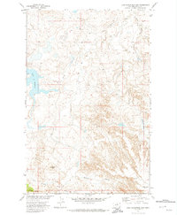
1971 Map of Lake Seventeen East
USGS Topo · Published 1974About this map
The Fort Belknap Indian Reservation landscape in north-central Montana is defined by the high plains topography of Blaine County. This 1971 survey illustrates a region where water management and natural drainage dictate the character of the land, centered around the significant waters of Lake Seventeen and the elongated Skinners Lake. To the south, the terrain rises toward Timber Ridge and the prominent Squaw Butte, features that overlook a network of seasonal drainages including Little Suction Creek and Running Crane Creek. The map provides a detailed view of the land before significant modern development, showing the relationship between family-named landmarks like Warneke Coulee and Warneke Flat and the broader environmental context of the Missouri River Basin development program.
Find a feature on this map
12 named features on this map. Tap any name to fly to it.
Don’t see what you’re looking for? This feature index may not catch every label — zoom into the map to look around manually.
Map Details
Editions of this 1971 Lake Seventeen East Map
This is the sole edition of this map. No revisions or reprints were ever made.
Other maps of this area

1943 · Landusky
USGS Topo · 1:125,000

1953 · Havre
USGS Topo · 1:250,000

1954 · Lewistown
USGS Topo · 1:250,000

1957 · Havre
USGS Topo · 1:250,000

1958 · Havre
USGS Topo · 1:250,000

1959 · Lewistown
USGS Topo · 1:250,000

1971 · Crazyman Coulee
USGS Topo · 1:24,000

1971 · Putnam Lake
USGS Topo · 1:24,000

1971 · Hays
USGS Topo · 1:24,000

1971 · Lodge Pole NW
USGS Topo · 1:24,000