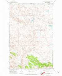
1971 Map of Lake Seventeen West
USGS Topo · Published 1974About this map
Timber Ridge dominates the southern landscape of this Blaine County quadrangle, where the terrain transitions into the drainages of Suction Creek and Little Suction Creek. The area is defined by its position along the eastern edge of the Fort Belknap Indian Reservation Boundary, a significant cultural and administrative line that bisects the eastern portion of the sheet. The landscape reflects a sparsely populated ranching or resource-focused environment in the early 1970s, evidenced by isolated infrastructure such as a Well and a network of improved and unimproved roads.
Find a feature on this map
8 named features on this map. Tap any name to fly to it.
Don’t see what you’re looking for? This feature index may not catch every label — zoom into the map to look around manually.
Map Details
Editions of this 1971 Lake Seventeen West Map
This is the sole edition of this map. No revisions or reprints were ever made.
Other maps of this area

1943 · Landusky
USGS Topo · 1:125,000

1953 · Havre
USGS Topo · 1:250,000

1954 · Lewistown
USGS Topo · 1:250,000

1956 · Rattlesnake
USGS Topo · 1:62,500

1957 · Havre
USGS Topo · 1:250,000

1958 · Havre
USGS Topo · 1:250,000

1959 · Lewistown
USGS Topo · 1:250,000

1971 · Crazyman Coulee
USGS Topo · 1:24,000

1971 · Putnam Lake
USGS Topo · 1:24,000
1971 · Lake Seventeen NE
USGS Topo · 1:24,000