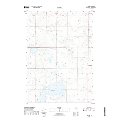
2017 Map of Lake Sinai
USGS Topo · Published 2017About this map
Lake Sinai and its surrounding wetlands define the landscape of this Brookings County quadrangle. Situated upon the Coteau des Prairies, the terrain is characterized by a high concentration of glacial depressions and small water bodies that underscore the region's unique geography. The settlement of Arlington occupies the northwest corner of the sheet, while the smaller locality of Ahnberg sits further east along 212A St. Local history is anchored by the Bangor Cem near Brush Lake, providing a clear focal point for genealogical research. The map illustrates a dense grid of township roads, including 457th Ave and 211th St, which trace the section lines typical of the Dakotas' agricultural development. This survey reflects the persistence of the rural prairie landscape in the early 21st century, showing how modern transportation routes continue to follow the early land survey patterns.
Find a feature on this map
30 named features on this map. Tap any name to fly to it.
Don’t see what you’re looking for? This feature index may not catch every label — zoom into the map to look around manually.
Map Details
Editions of this 2017 Lake Sinai Map
This is the sole edition of this map. No revisions or reprints were ever made.
Other maps of this area

1953 · Watertown
USGS Topo · 1:250,000

1958 · Watertown
USGS Topo · 1:250,000

1968 · Lake Sinai
USGS Topo · 1:24,000

1968 · Bruce
USGS Topo · 1:24,000

1968 · Arlington
USGS Topo · 1:24,000

1968 · Volga
USGS Topo · 1:24,000

1968 · Arlington NE
USGS Topo · 1:24,000

1968 · Sinai
USGS Topo · 1:24,000

1968 · Badger
USGS Topo · 1:24,000
1968 · Madison NW
USGS Topo · 1:24,000