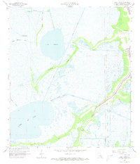
1964 Map of Lake Theriot
USGS Topo · Published 1973About this map
Lake Theriot and the expansive waters of Lake De Cade dominate this coastal Louisiana landscape, reflecting a region defined by its complex network of natural bayous and industrial waterways. Settled activity is concentrated along the narrow natural levee of Bayou du Large, where the small community of Theriot and the Lower Bayou du Large Sch are situated. The 1960s environment captured here shows an era of intensive resource extraction, indicated by the South Sunrise Oil and Gas Field and several marked Oil Wells. The map also reveals the engineered transformation of the wetlands through features like the Marmande Canal, Minors Canal, and the Falgout Under Construction Canal. Amidst this modern industry, ancient history is preserved at the Indian Mound near the eastern marshes, while named landforms like Congo Island and the Ridge provide topographic variety in the surrounding marshes.
Find a feature on this map
24 named features on this map. Tap any name to fly to it.
Don’t see what you’re looking for? This feature index may not catch every label — zoom into the map to look around manually.
Map Details
Editions of this 1964 Lake Theriot Map
3 editions found
Other maps of this area

1892 · Gibson
USGS Topo · 1:62,500

1892 · Houma
USGS Topo · 1:62,500

1894 · Bayou De Large
USGS Topo · 1:62,500

1894 · Dulac
USGS Topo · 1:62,500

1897 · Gibson
USGS Topo · 1:62,500

1932 · Houma SW
USGS Topo · 1:31,680

1935 · Theriot
USGS Topo · 1:31,680

1935 · Lake Mechant
USGS Topo · 1:31,680

1935 · Lake Quitman
USGS Topo · 1:31,680

1935 · Lake Gero
USGS Topo · 1:31,680