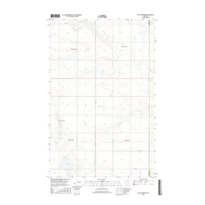
2017 Map of Lake Thibadeau
USGS Topo · Published 2017About this map
Lake Thibadeau and Grassy Lake define the southern wetlands of this northern Montana landscape, where the open plains of Hill County meet the Blaine County line. This area is characterized by a network of drainage features like Lohman Coulee and Lodge Cr, which navigate the subtle elevation changes of the high prairie. The land is organized by a strict grid of section lines and rural thoroughfares, including Shepherd Rd and Rd 170 N, supporting the agricultural operations of the region. Evidence of modern land management is visible through the inclusion of several private access points, such as Pvt Field Rd and Pvt Crop Rd, alongside a notable Diversion structure near the coulee that suggests managed water flow for local irrigation or livestock.
Find a feature on this map
18 named features on this map. Tap any name to fly to it.
Don’t see what you’re looking for? This feature index may not catch every label — zoom into the map to look around manually.
Map Details
Editions of this 2017 Lake Thibadeau Map
This is the sole edition of this map. No revisions or reprints were ever made.
Other maps of this area

1904 · Yantic
USGS Topo · 1:62,500

1904 · Havre
USGS Topo · 1:62,500

1912 · Zurich
USGS Topo · 1:125,000

1912 · Thibedeau Lake
USGS Topo · 1:125,000

1953 · Havre
USGS Topo · 1:250,000

1957 · Havre
USGS Topo · 1:250,000

1958 · Havre
USGS Topo · 1:250,000

1964 · Havre NW
USGS Topo · 1:24,000
1964 · Reservoir Coulee
USGS Topo · 1:24,000
1964 · Havre NE
USGS Topo · 1:24,000