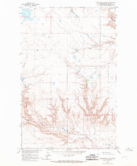
1964 Map of Reservoir Coulee
USGS Topo · Published 1967About this map
Lodge Creek meanders across the northern plains of Blaine County in this mid-century topographic survey, where the geography is defined by the deep incisions of semi-arid drainage systems. The landscape is dominated by the prominent Reservoir Coulee, which carves a significant north-south path through the center of the sheet, revealing the underlying geological erosion patterns typical of the Missouri River Basin development area. To the west, the branching networks of Badger Coulee and Redrock Coulee intersect, providing a clear record of the watershed's natural drainage before extensive modern land alteration. This map captures the remote character of north-central Montana, documenting the specific ranching and fence lines that partitioned these grazing lands during the early 1960s.
Find a feature on this map
4 named features on this map. Tap any name to fly to it.
Don’t see what you’re looking for? This feature index may not catch every label — zoom into the map to look around manually.
Map Details
Editions of this 1964 Reservoir Coulee Map
This is the sole edition of this map. No revisions or reprints were ever made.
Other maps of this area

1904 · Yantic
USGS Topo · 1:62,500

1904 · Havre
USGS Topo · 1:62,500

1912 · Zurich
USGS Topo · 1:125,000

1912 · Thibedeau Lake
USGS Topo · 1:125,000

1953 · Havre
USGS Topo · 1:250,000

1957 · Havre
USGS Topo · 1:250,000

1958 · Havre
USGS Topo · 1:250,000

1964 · Telescope Coulee
USGS Topo · 1:24,000

1964 · Havre SE
USGS Topo · 1:24,000
1964 · Lohman SE
USGS Topo · 1:24,000