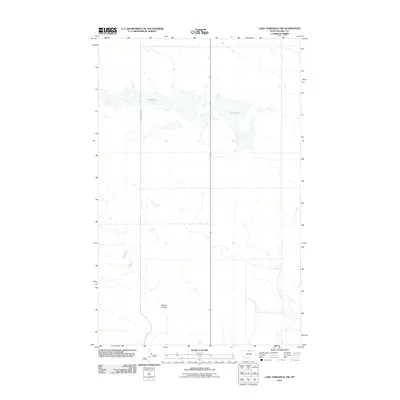
2011 Map of Lake Thibadeau SW
USGS Topo · Published 2011About this map
Mud Lake dominates this northern Montana landscape in Hill County, where the sprawling, shallow water body splits across the northern half of the survey. The terrain is defined by the ephemeral drainage patterns typical of this part of the state, most notably Staton Coulee, which winds through the southern portion of the quadrangle. Human infrastructure is minimal in this rural expanse, characterized primarily by long-distance transit routes like Willow Creek Rd. The map illustrates the specialized hydrology of the region, where coulees and seasonal lakes provide the primary relief in an otherwise subtle, open landscape used for large-scale ranching and agriculture in the early 21st century.
Find a feature on this map
3 named features on this map. Tap any name to fly to it.
Don’t see what you’re looking for? This feature index may not catch every label — zoom into the map to look around manually.
Map Details
Editions of this 2011 Lake Thibadeau SW Map
This is the sole edition of this map. No revisions or reprints were ever made.
Other maps of this area

1904 · Havre
USGS Topo · 1:62,500

1904 · Assinniboine
USGS Topo · 1:62,500

1912 · Thibedeau Lake
USGS Topo · 1:125,000

1953 · Havre
USGS Topo · 1:250,000

1957 · Havre
USGS Topo · 1:250,000

1958 · Havre
USGS Topo · 1:250,000

1964 · Havre NW
USGS Topo · 1:24,000
1964 · Havre NE
USGS Topo · 1:24,000
1970 · Quigley Coulee
USGS Topo · 1:24,000

1972 · Hilldale Colony
USGS Topo · 1:24,000