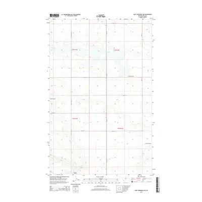
2014 Map of Lake Thibadeau SW
USGS Topo · Published 2014About this map
Mud Lake dominates the upper-central portion of this High Plains landscape in Hill County, where the terrain is defined by its seasonal drainage patterns and a precise grid of rural roadways. The intermittent waters of the lake and the winding paths of Lohman Coulee and Staton Coulee illustrate the characteristic erosional features of this northern Montana prairie. A strictly maintained section-line road network, including Willow Creek Rd and Road 515 N, facilitates travel through the vast agricultural and grazing lands of the region. State highway Mt-233 bisects the area, serving as a primary north-south artery. The map provides a detailed view of the Public Land Survey System divisions, showing the corners of four townships where they meet in this open expanse of the Big Sky Country.
Find a feature on this map
15 named features on this map. Tap any name to fly to it.
Don’t see what you’re looking for? This feature index may not catch every label — zoom into the map to look around manually.
Map Details
Editions of this 2014 Lake Thibadeau SW Map
This is the sole edition of this map. No revisions or reprints were ever made.
Other maps of this area

1904 · Havre
USGS Topo · 1:62,500

1904 · Assinniboine
USGS Topo · 1:62,500

1912 · Thibedeau Lake
USGS Topo · 1:125,000

1953 · Havre
USGS Topo · 1:250,000

1957 · Havre
USGS Topo · 1:250,000

1958 · Havre
USGS Topo · 1:250,000

1964 · Havre NW
USGS Topo · 1:24,000
1964 · Havre NE
USGS Topo · 1:24,000
1970 · Quigley Coulee
USGS Topo · 1:24,000

1972 · Hilldale Colony
USGS Topo · 1:24,000